These Maps Show Just How Different You Are From Americans In Other States

Maps of the United States often divide Americans into two groups based on how they vote, ignoring the real stark differences that exist between its citizens. While it’s clear that Americans are split, the Internet has provided some fascinating visual displays that truly highlight how varied America is on a number of topics and views.
Whether it’s seeing that Minnesotans are the most depressed, that Illinoisans are the most ashamed, or seeing which state’s residents confess to Google that they’ve cheated on their partner, these amazing maps showcase a ton of interesting information. Take a look at the United States through a truly unique lens that would’ve made high school geography way more interesting…
Brand Loyalty
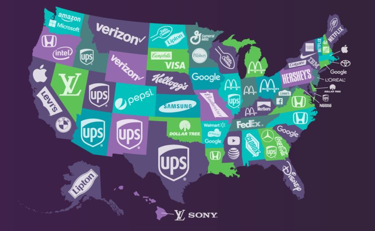
Along with a love for food and sports, Americans certainly are very much into shopping. People in the U.S. tend to be pretty brand loyal, often sticking with the company names they love. According to this map from 2018, an affinity for a brand depends on where you live.
Unsurprisingly, Hershey dominates Pennsylvania, and Disney is a mainstay in Florida (at least until the time being), while Amazon and Microsoft are big in Washington where their headquarters are. With Netflix growing exponentially over the last few years, a future map may see the streaming platform in a lot more states beyond the Northeast.
Relationship Advice
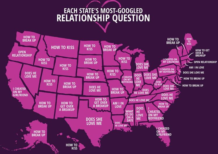
Again, people are turning to the all-knowing search engine Google for what to do, specifically regarding their relationships. While the United States may seem to be divided in many ways, this map should give people some hope that people have more in common than we realize.
An overarching trend seems to be people questioning whether or not their partner really loves them. Others are looking for the best way to let their significant others down more easily, knowing it’s time to move on. Sadly, a good number of residents in states like California, Illinois, New York, and Florida have admitted to Google about infidelity.
The Orange And Red Areas Have The Same Population Sizes
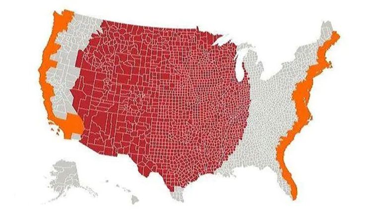
The population dispersal in the United States is really fascinating. People often gravitate toward the east and west coasts and end up cramming themselves into small areas with very high populations. Nearly half the population lives within 30 miles of a coast.
In this map, you can see that the small orange slivers are equal to the entire population shown in red. If you’re looking for a bit more space, you may consider leaving the coast and moving inland for a bit more breathing room.
Earthquake History
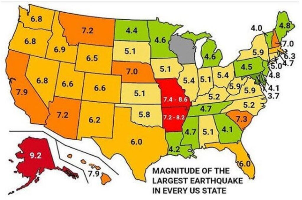
While California is the state most known for its frequent seismic activity, nearly every state across the US has had documented reports of earthquakes that can shake residents to their core. Although its population is much smaller, Alaska actually has had the most powerful earthquake in the United States to date.
When it comes to the Richter Scale measurement, a quake of 7.0 is ten times stronger than one that measures at 6.0. An earthquake that registers at 7.2 is 100 times more powerful than a 5.1. Of course, frequency plays a role as well, with some states that are in the West experiencing them more often and on a larger magnitude than the Midwest, South, or Northeast.
How Much Snow Does It Take To Cancel Schools?
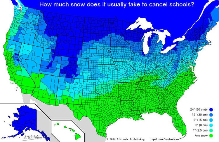
Not much if you live in the South. For many Southern states, all it takes is “any amount of snow” to shut down schools. For the Upper Midwest and Northeast, two feet of snow would have to fall before schools shut down.
It’s worth noting that school closures say more about an area’s infrastructure rather than the toughness of its citizens. Schools in the South will close for the smallest amount of snowfall because they don’t have the resources to clear snow the way Northern states can.
“Worst State To Live In”
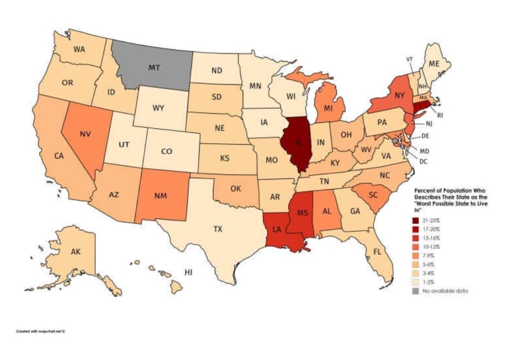
Natives of a town or country are often fiercely proud of where they live, often telling visitors why they should move there. Sometimes though, residents aren’t too enthused with where they’ve settled. With Illinois having over twenty percent of residents calling it “the worst state to live in” it’s possible some of that hate comes from Chicago’s cold weather.
People in Nevada are slightly less ashamed than New Yorkers, so maybe what happens in Vegas doesn’t stay there. Some of this dissatisfaction these residents may be facing may be related to having a different political opinion than their state. It wouldn’t be surprising if residents that rank their state as the worst end relocating more than others.
Sources For News
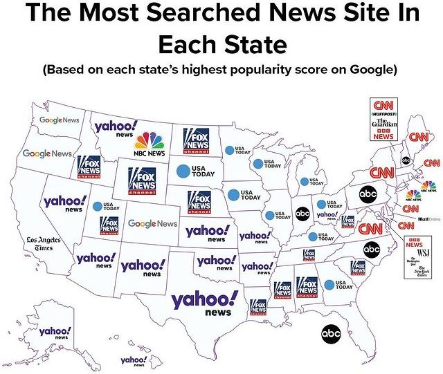
It’s no secret that the United States finds itself at a bit of a divide on a whole host of issues, with varied political opinions being at the core of that split. Some of the heated arguments between Americans are likely coming because of the different sources that people are getting their news from.
While much of the East Coast gets its information from CNN and NBC News, much of the Southern states are watching Fox News. A good percentage of the country also goes to USA Today and Yahoo! News to check what’s happening. As each company provides its own particular take and biases on national and world events, this could easily explain much of the polarization in America.
State Size By Population
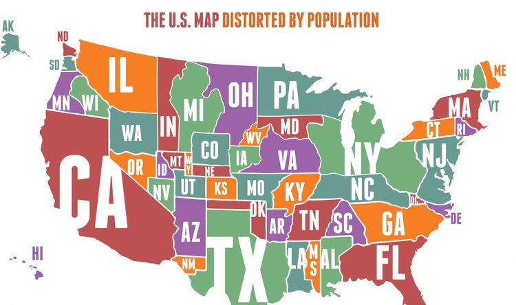
When looking at a map of the United States, it’s quite misleading for many how populated some states are (and the ones that aren’t) since we’re often so focused on their land mass. This map shows us what it would look like if the size of each state was representative of its population.
States like New Jersey are quite small in land mass, but quite significant when it comes to population numbers. Conversely, states that are much larger in area like Wyoming or Montana, end up looking rather tiny when you look at the number of residents per state.
College Debt
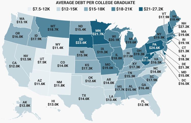
A college degree used to be regarded as an advantageous, esteemed way of distinguishing yourself in your career path. Now, not only is it essentially a prerequisite to most careers, but the price tag of higher education has gotten out of hand, as evident from this map that depicts the debt from the 2016 graduating class.
Aside from some of the more fortunate students, it’s become more of a certainty for many to have crippling amounts of debt upon graduation, which won’t necessarily be paid off so easily. This map gives some insight into which states are more expensive for schooling, especially compared to average personal income. With Ivy League schools being popular in the Northeast, students there are spending much more on those degrees than many others around the country.
Baseball Love
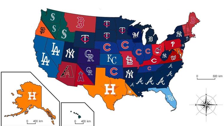
While football has a fandom of its own, baseball is still known to be America’s pastime. Compared to football, however, baseball does a poorer job of representing each state with their own team. As such, many residents of states without teams are forced to simply root for the nearest one, or in some cases, like the Red Sox fans of Montana, a random one.
The Chicago Cubs and Minnesota Twins happen to be quite popular all over the Midwest, with the Astros mostly being loved in Texas, as well as Alaska, surprisingly. The Red Sox and Yankees naturally are rivals over being the favorites in the Northeast, with the Atlanta Braves popularity being big in the South.
Salary For A House
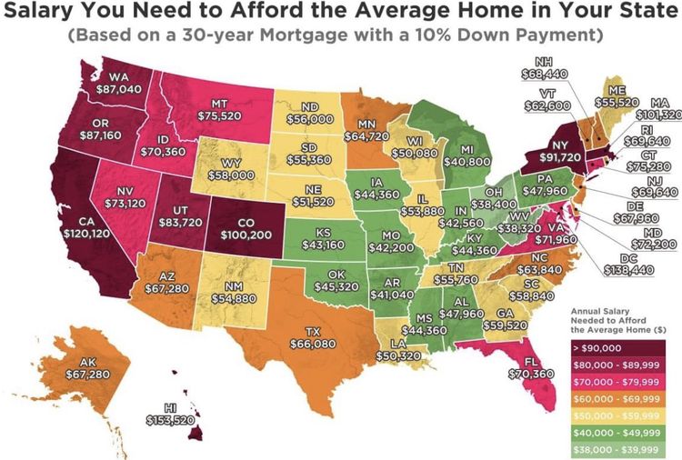
It’s a bit crazy to contemplate the large differences that exist in the cost of living in various parts of the United States. Seeing how much of a salary is needed can certainly be a reality check for most people when deciding where they want to live. With the housing market at a very high level since 2020, these numbers may even go up higher over the coming years.
If you’re getting close to retirement, think twice about moving out West. You’ll need to make nearly a six-figure salary if you want to break even, as almost every Western city boasts hefty house prices. If you’re open to a side hustle, however, you might do just fine.
Salary For An Apartment
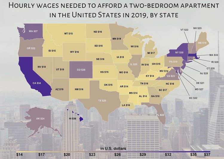
New York and California are some of the popular states to live in, but once you and your roommate discover that your monthly wages will cover an apartment that’s a bit larger than a shoe box there, you might consider living elsewhere. This map shows just how much people need to earn per hour to afford the rent of a two-bedroom apartment.
If your position offers a bit more flexibility, it may be a good idea to consider moving to a state where you don’t have to donate your life savings to your landlord. This map covers all the gory details and offers a practical snapshot of what those monthly living expenses are per state.
The Most Popular TV Shows Set In Each State
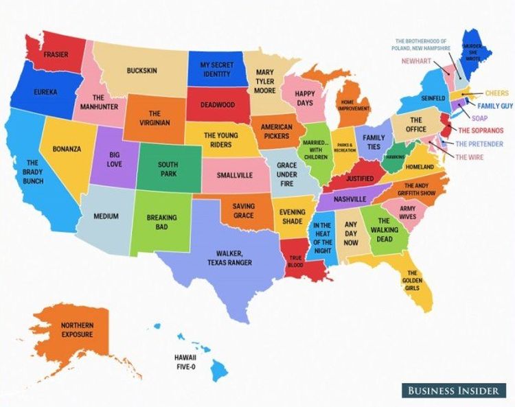
Do you think you can guess what the most popular show set in each state is? Guess again. While there are some obvious picks — The Office for Pennsylvania, Breaking Bad for New Mexico — more than a few series representing their states are true surprises.
In so many series, the location is paramount to the show’s storyline. Would Seinfeld have been as entertaining and successful if it was filmed in South Dakota? We don’t think so. That’s what makes this map so interesting.
Health And Wellness
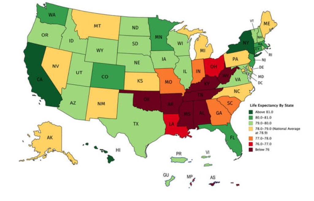
Whoever said that your geographical location doesn’t play a factor in longevity may have been slightly mistaken. Whether this is due in part to cleaner air, water, better eating, or more outdoor living, there are clear differences across the states in how long people tend to live.
California and New York are at the top of the list when it comes to having residents that are around longer. It looks like there is a stark contrast between Florida and some other Southern states. If you’re looking to extend your years, you may want to steer clear of some parts of the Deep South.
Population Born Outside of The US
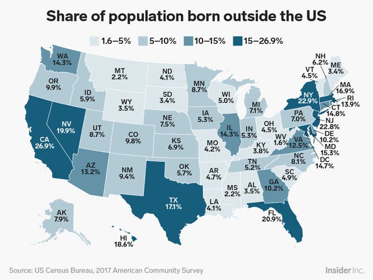
This map shows just how varied the US population is. Immigration continues to be a hot topic in US politics, and using data from 2019 on the number of residents who identified as foreign-born, the following map highlights the percentage of each state’s population born outside the US.
California has the highest number of residents who were born elsewhere, with 26.7% of the 39.5 million people born outside the US. New Jersey and New York follow closely behind at 23.4% and 22.4%, respectively. West Virginia has the smallest share, with only 1.6% of its population born outside of the US.
Speed Limits
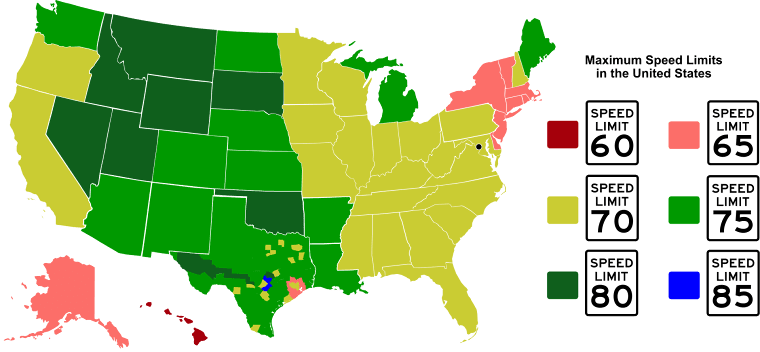
There’s nothing quite like the feeling of speeding down a wide-open highway, with music blaring and the wind in your hair. But before you go all “Thelma and Louise” on your next road trip, peruse this map to avoid the long arm of the law when flying down those roads in another state.
While most states happen to have a pretty similar maximum speed, it’s always a good idea to check how fast you can go before embarking on your next excursion. A hefty ticket from a stickler of a state trooper is one way to put a damper on your vacation, so be on the lookout.
Football Fandom
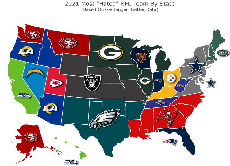
Football fans are passionate about the teams they love and might be even more emotional about the teams they hate. This map gives an interesting insight into some of the deep-seated rivalries in the NFL. Naturally, Illinois and Wisconsin have the Chicago Bears and Green Bay Packers as bitter rivals, being some of the oldest teams in the league.
With quarterback Tom Brady leading New England to success for nearly two decades, Dolphins fans in Florida have some ill will toward the Patriots. Brady’s last hurrah with the Tampa Buccaneers before his retirement in 2022, has likely the Bucs to be pretty despised in the South. While the Los Angeles Rams only appear in a couple of states in 2021, their winning of the Super Bowl in 2022 will probably add a few more haters.
Depression Rates
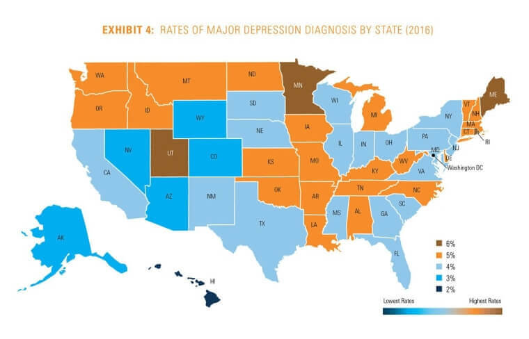
Depression is a pervasive problem in many countries in the world, and the United States is certainly no exception. The potentially-debilitating condition affects people of all ages and from all walks of life, so it’s something that should be on people’s radar. It’s also likely that given the recent state of the world, these percentages have increased over the last couple of years.
Understandably, colder climates like Minnesota and Maine tend to be higher on the scale, with depressive moods being more common in the winter months because of what’s called seasonal affective disorder. To little surprise, Hawaiians are the lowest on the list, so maybe there’s something to living in a vacation spot.
Beer Consumption
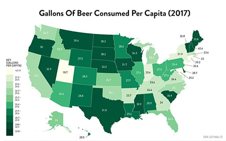
Americans certainly are known to enjoy a beer or two. It’s why so many Super Bowl commercials are from Budweiser and others. This map shows you how much drinking of beer is done by each state, with Nevada being one of the leaders, as many bachelor parties and impromptu weddings have been aided by inebriation.
Knowing the number of calories that beer has in it, it shouldn’t surprise people that more health-conscious states like California and New York tend to rake lower on the list. Wisconsin, home to some well-known breweries, is near the top of the list, with some of the colder states consuming more beer than the rest of the country, possibly to keep warm.
Turkeys Raised
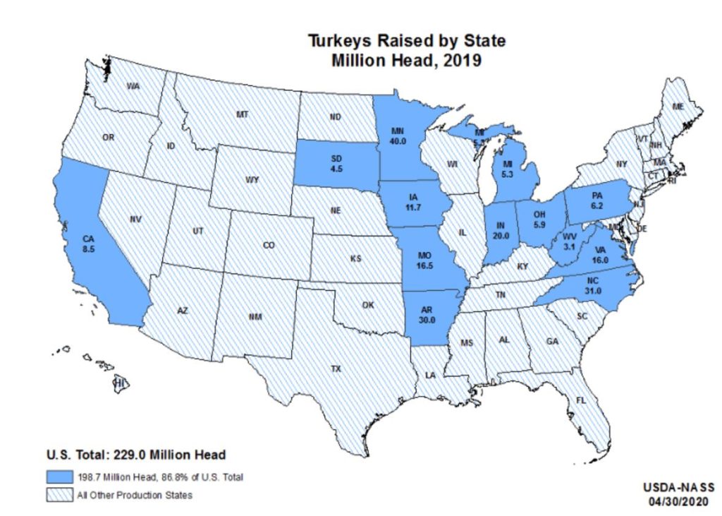
What would Thanksgiving be without the traditional meal of turkey, stuffing, cranberries and pumpkin pie? November has become synonymous with practicing gratitude, gathering together with family and friends, watching football, and some over-the-top gluttony.
While you’re packing up all those leftovers, check out this map detailing the precise locations where you can score a turkey. The number of turkeys tend to be most common in the Midwest, with California representing the West Coast. Fascinatingly enough, more than 85% of the turkeys raised only come from about a dozen states.
Music Choices
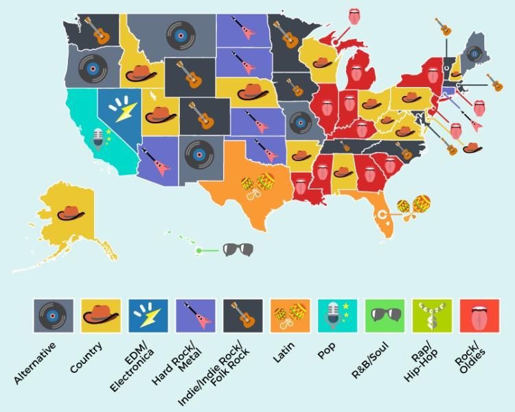
Like a lot of other topics in the United States, when it comes to the type of music that people prefer, there are a good amount of opinions about which is the best. Those musical interests certainly vary depending on the state you may find yourself living in.
At a glance, it’s clear that states with many native-Spanish speakers, such as Texas and Florida have a preference for Latin music, while heavy metal is popular in some of the Great Plains states. Hawaii tends to favor some R&B, with oldies and country music being popular in the rest of the country.
Breakfast Chains
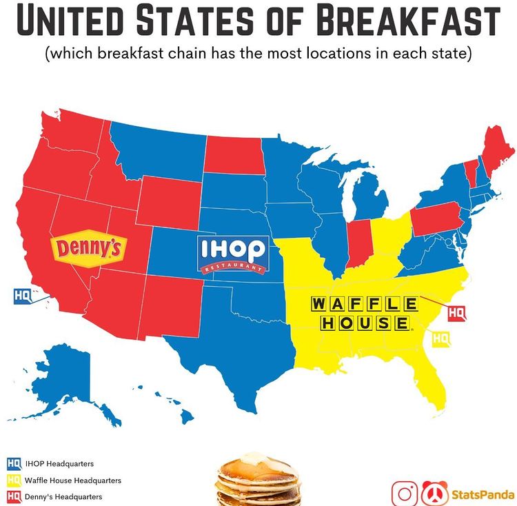
Breakfast chains are a huge part of the American economy, with the three most popular restaurants being IHOP, Waffle House, and Denny’s. With these companies having 1,666, 1,484, and 2,100 locations all over the country, respectively, it’s pretty clear that these eateries dominate the morning dining experience.
Interestingly enough, each of these big three companies has its own territory. Denny’s is primarily popular on the West Coast, IHOP in the Midwest and parts of the Northeast, and Waffle House covering the South. Half the states don’t have a Waffle House, while IHOP and Denny’s have locations in every state.
Soft Drink Nicknames
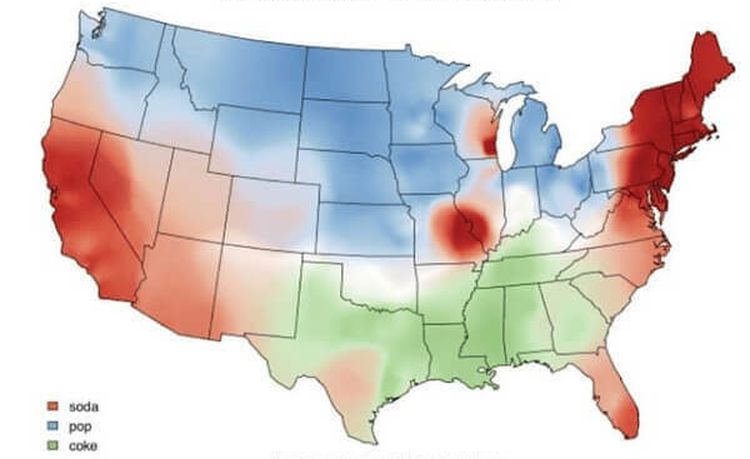
The hotly-contested debate as to what to call drinks has raged in the United States for decades at this point. Since the invention of fizzy drinks were bought at the local drugstore, people have differed in the way they refer to their favorite flavored beverages and soft drinks.
This map will be your road guide to asking for the right beverage in the right place when you’re feeling particularly parched. Were you to walk into a store in Florida and ask for pop, they might send you right back outside, so know what you’re asking for, even if it sounds funny to you.
The Most Spoken Languages After English And Spanish
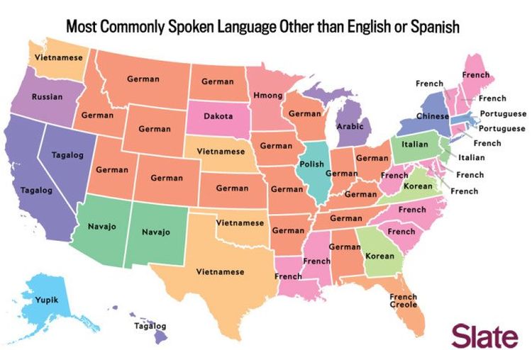
The United States is a melting pot when it comes to diverse cultures and languages. This map shows the most commonly spoken languages in the US after both English and Spanish. Who knew so many people speak German across the country?
German takes the lead after English and Spanish as the most commonly spoken language in the U.S. followed by French which is most common in eleven states plus D.C. Vietnamese comes after French as being the most common language in four states.
Googling What To Do
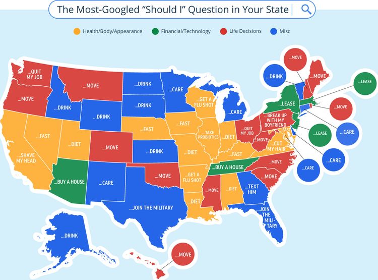
People spend a good portion of their time these days on the Internet, which happens to have a ton of useful (and not useful) information at our fingertips. So naturally, it’s the first place that people often turn to when it comes to figuring out some of their most pressing personal challenges.
This map shows that what people are asking Google often differs by state. One of the most common questions is if relocation will be an improvement in lifestyle (and that’s certainly only gone up in the last few years). People also look for health advice, pondering about dieting. It also may be a good idea to check in on some of the Dakota residents who are thinking about the bottle.
Voters Who Didn’t Vote For Trump Or Hillary
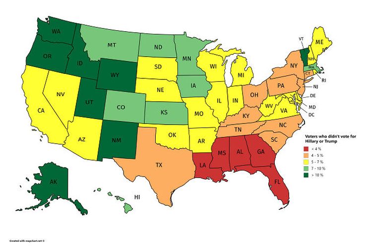
This map shows the percentage of voters in each state who voted in the 2016 Presidential election but didn’t vote for either Trump or Hillary. In 8 states, more than 10% of the voting population cast a ballot for someone other than the leading candidates.
Utah had the highest percentage of ballots cast for someone else that wasn’t Trump nor Hillary. A whopping 27% of voters chose another candidate. In Idaho, 13.25% of voters wanted someone else and following closely behind, 13.05% of Vermont’s voters also voted for another future president.
Unemployment Rate
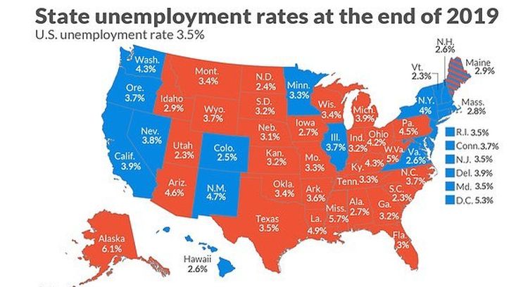
Americans will often hear on the news about the unemployment rates at a national level. Rarely is there a breakdown of what percentage of people are not working on a per-state basis. But it looks like with the national average being 3.5% as of 2019, most states end up hovering right around that mark.
Some states seem to be outliers for higher unemployment, such as Alaska, New Mexico, Arizona, and West Virginia, where their unemployed percentage is well beyond the national norm. This data may look very different in 2022, with unemployment having risen significantly in the last couple of years.
Trees
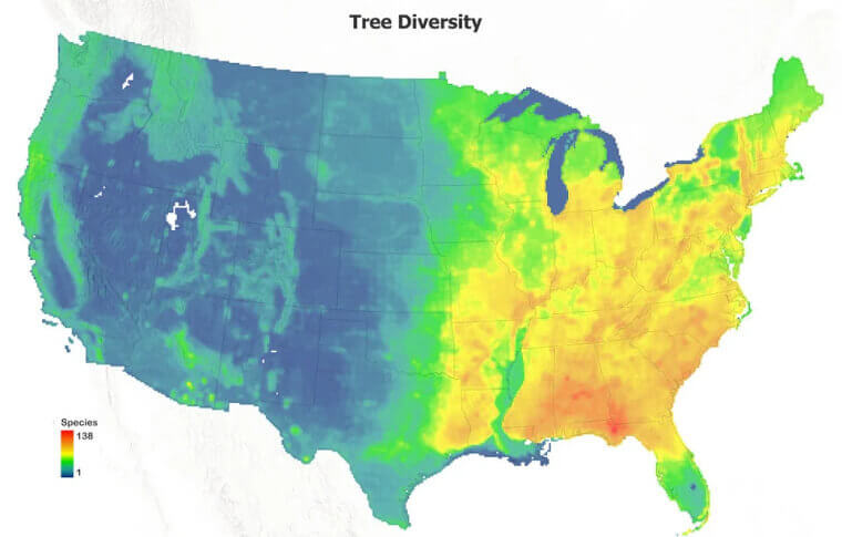
America is a land full of diversity, not only among its millions of people but also in its continually-changing landscape. Among the varied diverse features of the United States land is the impressive foliage and the trees that dot the landscape with natural beauty.
Nearly 100 different species of trees are able to be found in some parts of the U.S., with the East Coast being the most diverse by far. Nearly a thousand different species of trees can be found nationwide, so there’s a little something for everyone.
Most Common Birth Countries
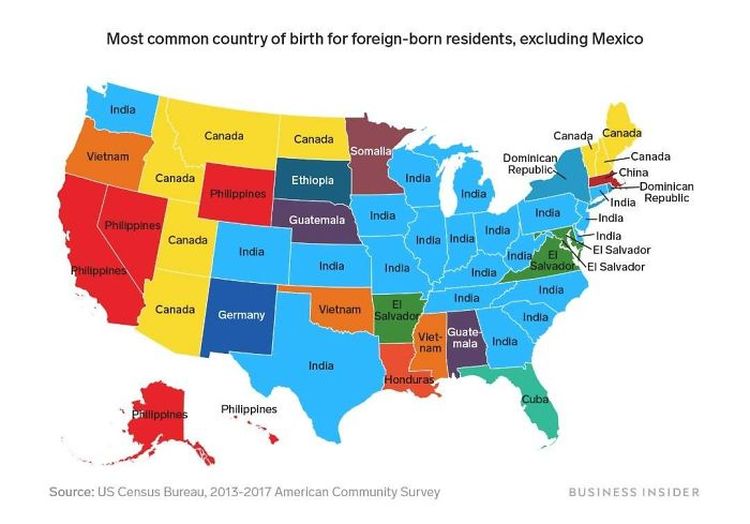
The US is a nation of immigrants from all around the globe. The percentage of the population born outside of the US varies widely from state to state. Within these immigrant populations, the countries of origin vary widely as well.
Using data from the US Census Bureau, this map shows the countries that were the most common birthplaces for foreign-born residents in each state (excluding Mexico, which was the most common birth country for immigrants in 32 states).
Favorite Snack
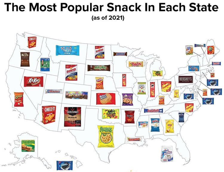
One of the things Americans have become known for is the tendency of eating unhealthily. This map of popular snacks around the country zeroes in on which brand of treats each state has a particular hankering for, with Oreos being a clear leader on the East Coast.
Hershey’s again is a favorite in its home state of Pennsylvania. It’s clear that 29 states prefer sweet foods over salty ones. Interestingly as well, most snacks are consumed from vending machines, and not convenience stores. This may be tied to people in their office looking for a quick snack during work and is a trend that may change with more people working remotely.
Countries Of Origin
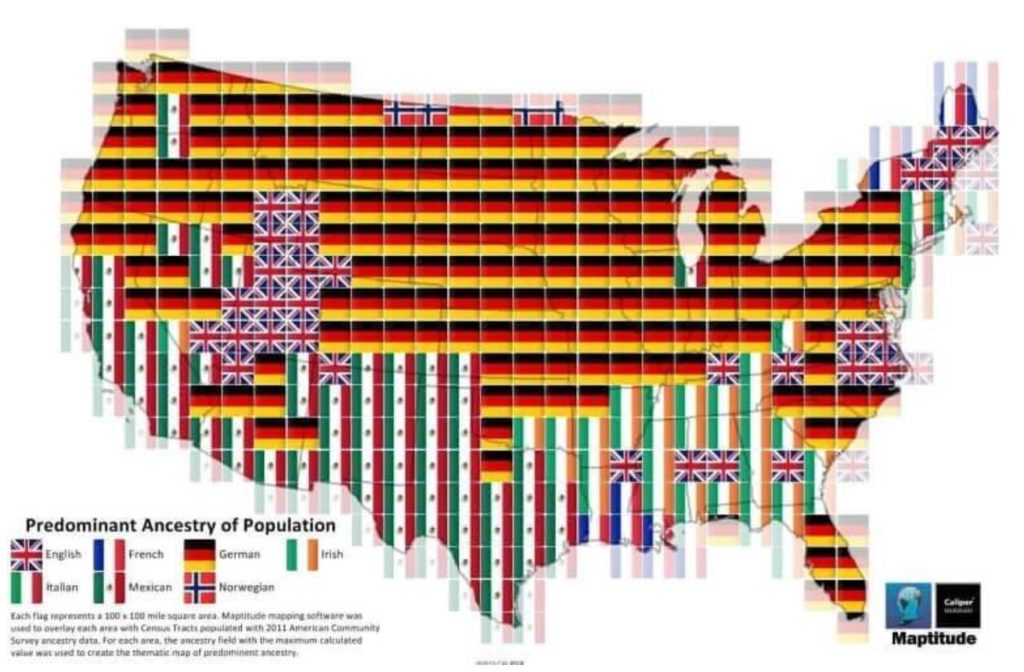
They don’t call the United States a melting pot for nothing. Between the years 1820 and 1930, over 6 million people from Germany and nearly 5 million from Ireland left their homeland in Europe and immigrated to the United States in the hopes of finding a better life.
This map is a fascinating display of those early pioneers and their migration patterns. What drew them here was a promise of better living, more opportunity, and a chance to create a whole new world for their families. While much of the U.S. can trace its lineage back to European countries, a solid amount of folks in the Southwest and California end up coming from Mexico.
Highest-Paid Public Employees
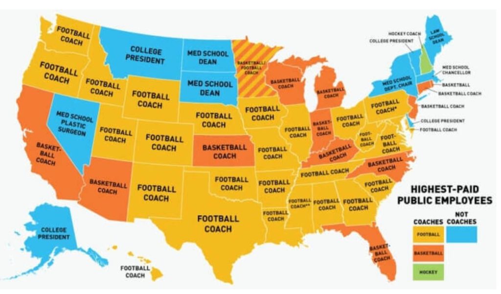
Americans tend to idolize their sports superstars, especially with some states having particularly popular college basketball and football programs. So it should come as no real shock that the highest-paid public employees happen to be the coaches for some of those schools, especially with that’s where a lot of revenue for colleges comes from.
Basketball and football coaches reign supreme, with heads of medical schools coming in at second. With nearly 80 percent of states having their coaches as the highest-paid public employees, this map showcases the popularity of sports culture, and how much successful collegiate programs can mean to local economies.
Loudness By State
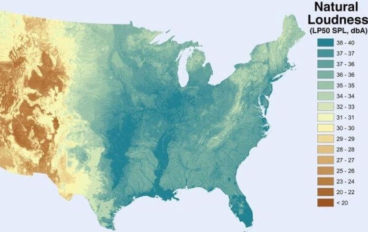
Few people stop to behold the beauty of nature as often as they may want to. Even fewer notice the natural music and sound that Mother Earth makes as all the elements come together in perfect harmony to create sound that can be measured in decibels.
This map is a snapshot of how loud parts of the country are, measured in decibels. The sound of the wind, weather patterns, water, animals, and even the movement of trees are captured and on display. The national parks that frequent the Northwest may be great spots to not just see nature, but hear it is as well.
Abandoned Railway Lines
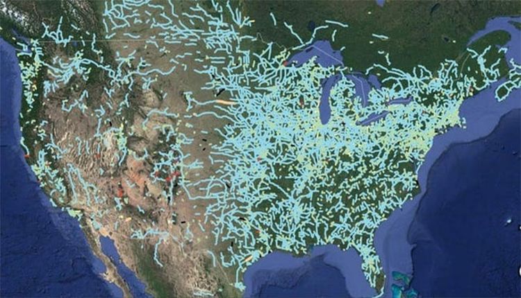
This abandoned rail lines map shows the hidden network of defunct railroads across the country. All across the US, there are scores of abandoned rail routes. You might even find a ghost network of rails close by that you can explore on your own.
You can see all the old train routes and fragmented railroad lines that have been lost to history throughout the years. Many were deserted and left to weather the tides, while others have been transformed into green footpaths for unwitting pedestrians, perfect for Sunday strolls and outdoor exploration.
Differences For “You All”
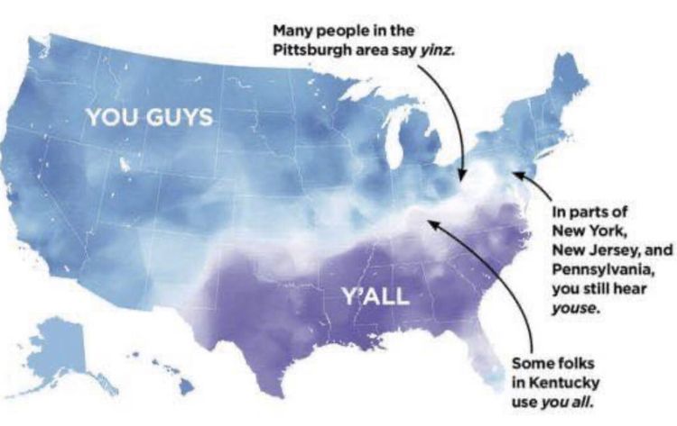
As divided of a country as America may be at the current juncture, there are simple, small ways to find commonality. Language and the way we speak is an easy bond to find. For instance, most states’ residents refer to a group of people in conversation, as “you guys.”
Addressing people as “y’all” is certainly the easiest way to spot if someone is from one of the Southern states. Interestingly as well, some locales have their own slang, like Pittsburgh residents saying “yinz” and residents in parts of New York, New Jersey, and Pennsylvania referring to people as “youse.”
Name Origin
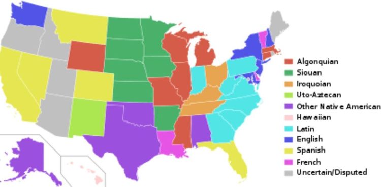
Those early pioneers of the United States didn’t waste any time carving out a new life and a new name for themselves. Among the many things they did was naming new territories and claiming them as their own, though they weren’t as original as you may have thought.
Many state names, as you can see from this colorful presentation, are derived from native words from various indigenous tribes. What many don’t realize is that less than a dozen U.S. states have English derivatives, further proof of what a melting pot of cultures and languages America really is.
Coffee Chains
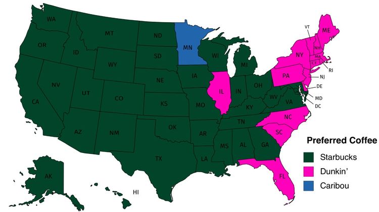
Americans are fiercely loyal to their preferred coffee brands. Coffee culture has certainly taken the world by storm, with people needing their morning fixes just to get started every day. It can cause some serious anxiety if you’re a ‘Bou fan from Minnesota having to go through a Starbucks drive-through while on vacation.
Not to worry, this map will clear all that coffee confusion up. It displays the largest coffee chain by state, with Starbucks looking like the clear winner across the country. Plan your road trip stops and drive-through breakfasts accordingly. It seems like America runs a lot more on Starbucks, and a lot less on Dunkin’.
Population Density

For those who need a little bit more of a visual presentation, this map exists to highlight the colossal differences between parts of the U.S. and their populations, when it comes to density. Note the concentration of people on each of the coasts, with much of the country having much more space.
New York, in particular, is a marvelous representation of just how densely populated Manhattan really is, and why it’s so hard to find a parking spot. Population numbers tower over the rest of the country much like a New York City skyscraper looms over the city skyline.
Land Distribution
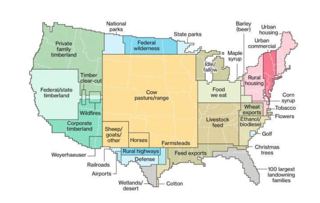
How are our amber waves of grain and purple mountain majesties being used these days? This map provides a visual look at how much of this country’s land is residential, and how much is commercial. Many of the farming resources are found in the middle of the country, with a lot of timber and wood being found in the Northwest.
Meant to be more of a representation of how America is using its land, one can see that the largest chunk of the area is for raising and feeding cattle. When you consider that there are far more people in the U.S. than there are cattle, perhaps some Americans may realize they can use some of that land for their own grazing.
Slang For Shoes
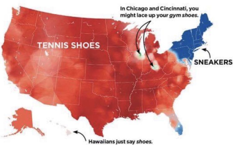
Here’s another map that provides more of what most people in the U.S. have in common more than what they don’t. For this map, we see that it depends on what area you grew up in when it comes to referring to the shoes that are used for more casual wear.
“Tennis shoes” is the name for them in an overwhelming part of the country, with the Northeast going holding their own by calling them “sneakers.” Of course, a couple of outliers exist, such as the folks from Chicago and Cincinnati knowing them as “gym shoes.” And people in Hawaii just know them simply as “shoes.”
Springfields
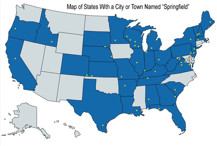
Fans of the beloved animated TV show, The Simpsons, know all too well that it is the longest-running show of all time, with over 700 episodes having been produced. The writers of the series have made it a big secret about which of the Springfields in the United States this funny family actually live in.
It’s purposefully ambiguous, but some have ventured guesses as to them being from Kentucky, Missouri, or judging by the Mayor’s accent, Massachusetts. This map really conveys just how many of the fifty states happen to have a town of Springfield, making the guessing game that much harder.
Fast Food
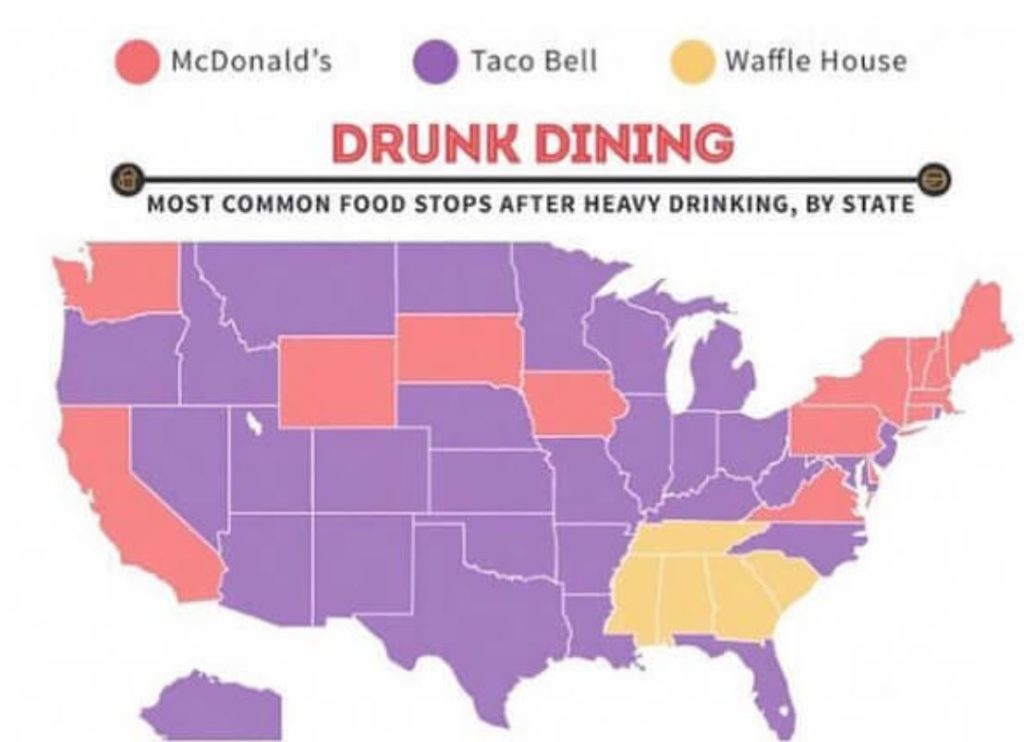
Aside for the most popular breakfast places in the country, Americans tend to also get a hankering that can only be satisfied by fast food late at night. And yes, a lot of these trips tend to happen when the customers are not quite sober, which fast food employees likely understand.
These hungry, under-the-influence visitors have a particular craving for a burrito, waffle, or burger. Their snack of choice differs depending on where in the United States these patrons live. While many in the Northeast grab a bite at Mcdonald’s, most of the rest of the country prefers something from Taco Bell, with many Southerners opting for the popular Waffle House, and may come back for breakfast as well.
Christmas Trees
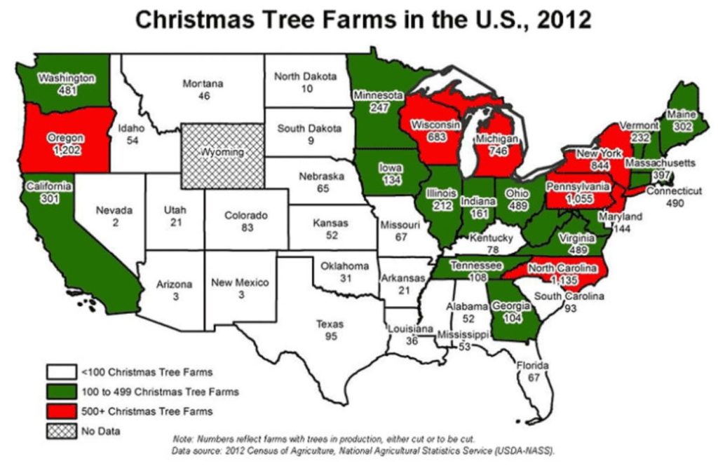
While on the topic of trees, when it comes to when to buy a Christmas tree, some try to get as early a start as possible, scouting out locations even in November. Millions of Americans celebrate Christmas every year and have come to rely on those dedicated Christmas tree farmers who produce festive foliage to help enhance the occasion.
While most states have at least a few tree farms, there are clear distinctions between those areas that are ripe for growth and those that choose to import the fragrant greenery. Families start turning up in droves in the late fall just to select their perfect tree.
Egg Production
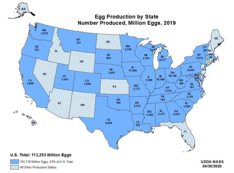
Over fifty billion eggs are laid each year in the US, with Iowa being the undisputed leader of the pack when it comes to egg production. Such a versatile and delicious food deserves its own representation, and we thank our loyal hens for their contributions.
This map shows egg production at its finest, with states like other states like Indiana, Texas, Pennsylvania, and Ohio following Iowa. With so many delicious options for cooking, baking, and culinary excellence, it’s no wonder Americans have come to rely on them so heavily.
Presidential Resting Places
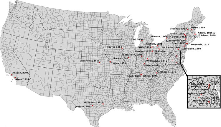
Many of the former Commanders-in-chief of the United States chose the Arlington National Cemetery as their final resting places. Still, others are laid to rest in or near their hometowns, next to loved ones and friends who have passed. This map is a representation of those former Presidents and where they have their gravesites.
A number of these Presidential plots were chosen by the men directly, while some have allowed their friends and family to carry out this final bidding as they close out a chapter in U.S. history. There are four former Presidents that are still alive, and the other 41 are scattered throughout the country, many of them in the Eastern part of the United States.
Immigrant Jobs
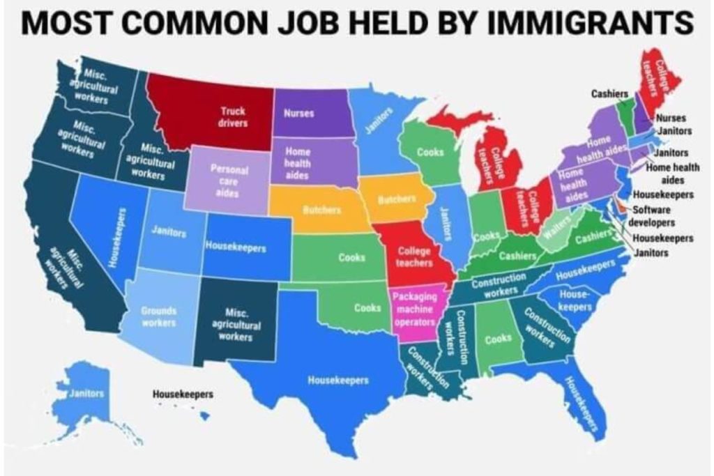
The pursuit of the American Dream is an idea that has pushed people to strive for success. The concept of making it big is held in the minds of many as they aim to work their way up the ladder toward success. Often, immigrants will come to the United States hoping for opportunities their native countries may not have afforded them.
With the barrier of entry for a new immigrant being a bit harder than for a native citizen in the United States, many of the jobs listed have a physical labor component to them. With a desire and a need to earn an income right away, many newcomers to America look for positions that require no schooling.
Pizza Chains
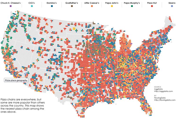
Pizza may be a product of Italy originally, but it’s certainly made its way into the hearts of Americans as a beloved staple. Sure, grabbing a slice from your local pizzeria is something special, but there is consistency and reliability that come from certain larger pizza chains.
This map showcases the most prevalent pizza chains across the United States. Pizza Hut seems to be popular in most states, especially in the Midwest, with Little Caesar’s looking like it’s a favorite in Michigan and Southern California. The West Coast has some significant locations of Papa Murphy’s, with Sbarro being especially popular in the Northeast.
Job Sectors
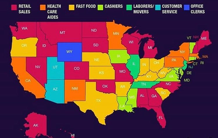
This map shows the most common categories of jobs that people have, depending on the state. This view from the Bureau of Labor of Statistics is from May of 2019, but the landscape may have changed with many states shutting down in-person offices in the middle of March 2020.
With many jobs being roles that cannot be done remotely, many Americans are finding that they are looking for work in a new field, in what some have called “The Great Resignation.” With the retail industry has taken a serious hit in the last several years, it’s unclear if retail sales will still be as popular in coming years.
The Greatest Sports
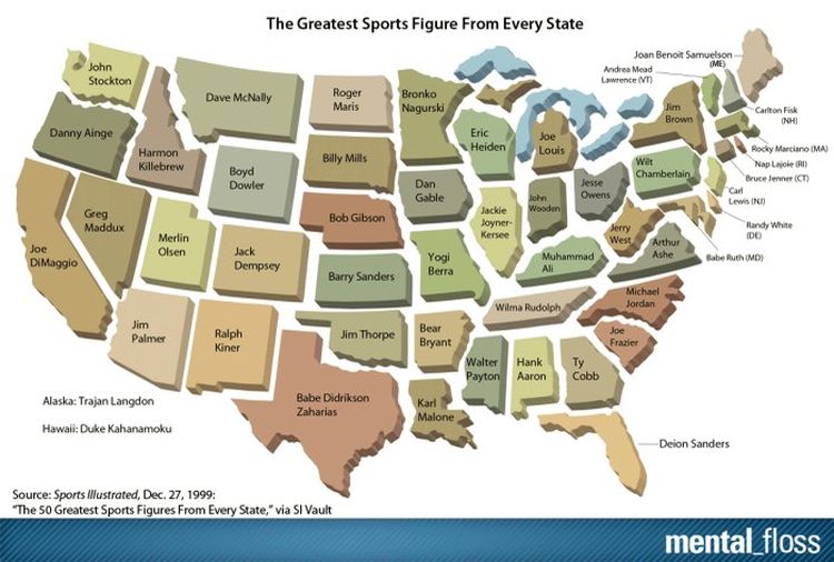
It’s by no surprise that baseball’s Babe Ruth takes the crown as Maryland’s state superstar. Or celebrated basketballers Michael Jordan, Karl Malone, and John Stockton claim top for their native North Carolina, Louisiana, and Washington, respectively.
It’s not only baseball and basketball that are celebrated. Turning our attention to the ring, one of America’s most celebrated athletes, Muhammad Ali, is easily the greatest athlete to come out of Kentucky. And Yogi Berra’s baseball heroics have cemented him as Missouri’s leading sportsman.
Orange Production
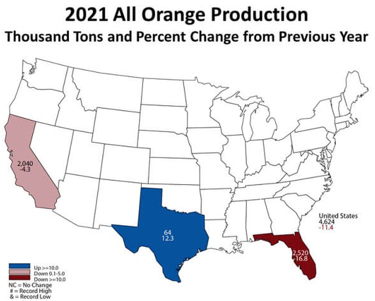
It’s always nice to start your day off with a fresh glass of orange juice for breakfast. While many states across the country take part in orange production, only a few made this map citing production percentages, increases, and decreases throughout the year.
States across the deep South are well-known for their citrus production, but it was surprising to see that Florida has dwindled significantly in the past year, while the big state of Texas continues to thrive and pump out that delicious golden fruit for our glasses.
Soybean Production
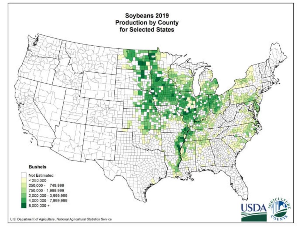
As much as Americans have gotten the reputation for eating unhealthily, many have embraced a more health-conscious approach to their diets Many have opted to pass on meat consumption in favor of of what they consider to be healthier, more sustainable source of protein in soy.
This map clearly outlines the production of soy across the country, with less production coming from the West than you may expect. Midwestern states are coming in first for supplying the country with the versatile crop, and health-conscious consumers are appreciative of every bushel being produced.
Country Expansion By Administration
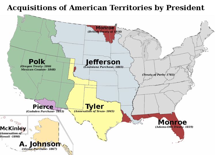
All U.S. Presidents entered the White House with the desire to leave their mark on American culture and history. In the 19th Century especially, an expected legacy as President was to acquire new land and territory on behalf of the United States. You can see which administrations are responsible for the expansion of the country.
One of the most famous acquisitions came in 1867, when under President Andrew Johnson, Secretary of State William Seward acquired Alaska from Russia for $7.2 million. The price of about 2 cents per acre famously became known as Seward’s Folly in the press, but in hindsight was quite the bargain. The Louisiana Purchase in 1803 would also set President Thomas Jefferson back an astronomical $15 million.
